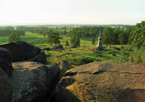
Photo of Little Round Top, at Gettysburg National Military Park, Pa., offers
a sweeping view. From this hill, on the left end of the Union line, Lt. Col.
Joshua Chamberlain led the 20th Maine Volunteers in a bayonet counterattack
against the 15th Alabama Infantry and other Confederate units on July 2,
1863.

Battlefields are where history happened—for better or for worse. As Winston Churchill once observed, “Battles are the punctuation marks in history.” Battles, however, are very complex events. You can read many books and look at countless maps and still not have the gut-level understanding of what really happened and why it happened that way. Thus, the classic military adage, “See the ground.” That’s sage advice whether you are planning to fight a battle or trying to understand it long after the fact. No two battles are the same—even battles fought on the same piece of ground at different points in history. The compositions of the opposing forces, the contemporary weapons technologies, the tactics of the period, and the weather the day the battle was fought are never the same. The ground, however, changes very little, and the terrain can often be the dominating factor in the battle. Broken and compartmentalized ground usually favors the defender, wide-open terrain habitually favors the attacker, and gravity always confers an advantage on the side that holds the high ground. Very little in the brave new world of cyber operations will help a military force conduct an opposed river crossing. Kinetic energy still counts. No two historical battlefields are alike. Some have been almost completely built over, while others have changed relatively little since the swords were sheathed or the guns fell silent. Fortunately, there are many excellent battlefields that are historically significant, comprehensible, visitor friendly and (mostly) easy to reach. On the following pages are photos of Military History ’s top recommended sites for any battlefield enthusiast’s bucket list.

Photo of Fort Ticonderoga, Ticonderoga, New
YorkBeautifully preserved Fort Ticonderoga, near the south end of upstate New York’s Lake Champlain, was the site of several battles in 1758–59, during the French and Indian War, and in 1775–77, during the American Revolutionary War. Photo of a early spring view of Martello Tower number 1,
one of the three remaining 19th century British Martello towers that form part
of the Fortifications of Québec National Historic Site of Canada on the Plains
of Abraham, National Battlefields Park, Québec City, Québec. The St. Lawrence
River can be seen in the background.This Martello tower was erected on Quebec’s Plains of Abraham a half century after British forces under Maj. Gen. James Wolfe climbed bluffs like those visible on the far side of the St. Lawrence River to defeat the French under Lt. Gen. Louis-Joseph de Montcalm on Sept. 13, 1759, amid the French and Indian War. A photo of Cannons at
Yorktown Battlefield, Virginia, USA. Yorktown Battlefield is the site of the
final major battles during the American Revolution and symbolic end of the
colonial period in US history.An 18th century cannon and a 19th century field gun stand side by side on the field at Yorktown, Va., which was both the site of the last major land battle of the American Revolution, in 1781, and a key Civil War battle during Union Maj. Gen. George McClellan’s Peninsula campaign, in 1862. A photo of a
marble marker stands where Lt. Col. George Armstrong Custer fell on June 25,
1876, at the Battle of the Little Bighorn.This marble marker stands where Lt. Col. George Armstrong Custer fell on June 25, 1876, at the Battle of the Little Bighorn. Photo of Little Bighorn Battlefield National Monument, MONTANA, USA - JULY
18, 2017: Tourists visiting Little Bighorn Last Stand monument obelisk and
Last Stand Hill grave yard.A memorial to the 7th U.S. Cavalry surmounts Last Stand Hill at Little Bighorn Battlefield. Markers on the field indicate where soldiers fell in combat against Sioux, Northern Cheyenne and Arapaho warriors.

this article first appeared in Military History magazine

See more stories

Subscribe now!

Military History magazine on Facebook Military History magazine on Twitter

Photo of a bird's-eye view of the Ancient 1st-century Fortress of Masada in
Israel from a drone.Ordered built by King Herod the Great in 31 bc atop a plateau near the Dead Sea, Masada was occupied by Jewish rebels during the First Jewish- Roman War. It fell in 73 after besieging Roman troops built a ramp to the very rim of the plateau. Photo of Carthage ruins on a sunny day,
Tunisia.The scenic ruins of the ancient city-state of Carthage, on the Mediterranean coast of Tunisia, speak to the devastation wrought on it by Roman besiegers in 146 bc during the Third Punic War. Photo of Battle
Abbey at Battle near Hastings, Surrey, England is the burial place of King
Harold, built at the battle field at the place were he fell, at the Battle of
Hastings in 1066, built in the 11th century it is now an ancient
ruin.Norman forces under William, Duke of Normandy, defeated Anglo-Saxon forces under King Harold II at the Oct. 14, 1066, Battle of Hastings. On the orders of William the Conqueror this Benedictine monastery, known today as Battle Abbey, was established on the field in 1094, its high altar constructed atop the spot where Harold fell in battle. The abbey ruins stand on Senlac Hill, some 6 miles northwest of the East Sussex town of Hastings. Photo of Troy horse imitation in the actual city of Troy
in Turkey.Somewhere in the mists of the 13th or 12th centuries bc Achaean Greeks conducted a long siege against the city of Troy, on the coast of present-day Turkey near the entrance to the Dardanelles. The archaeological site is on the outskirts of the town of Canakkale and features a large wooden reconstruction of the mythological Trojan Horse, for which no historical evidence exists aside from mentions in the works of Homer and Virgil. Photo of First World War One Fort de
Douaumont, Lorraine, Battle of Verdun, France.This view takes in the shell-damaged rear of Fort Douaumont, outside Verdun. During the 1916 battle German heavy artillery relentlessly shelled the French fortress before a single German pioneer infantry squad captured it on February 25. It took three French divisions to finally recapture Douaumont, on Oct. 24, 1916. Photo of Gunports in Fort Douaumont at Verdun,
FranceThis retractable, rotating turret on the roof of Fort Douaumont housed an automatic-firing 155 mm howitzer. In the background is one of the fort’s armored observation cupolas. Today the massive subterranean structure houses the most impressive museum in the expansive national battlefield park. Photo of the Gallipoli peninsula,
where Canakkale land and sea battles took place during the first world war.
Martyrs monument and Anzac Cove. Photo shoot with
drone.The Canakkale Martyrs’ Memorial commemorates the quarter million Turkish troops who fought off the landings by British Commonwealth forces in 1915–16. The memorial sits atop Hisarlik Hill in Morto Bay, just inside the mouth of the Dardanelles, at the south end of Turkey’s Gallipoli Peninsula Historical National Park. Photo of France, Normandie, Calvados
(14), Cricqueville en Bessin, pointe du Hoc entre Omaha beach et Utah beach
mÈmorial du dÈbarquement amÈricain du 6 juin 1944, vue aÈrienne * France,
Normandy; calvados; Cricqueville-en-Bessin; Pointe du Hoc, promontory with a
100 ft cliff. World War II it was the highest point between Utah Beach to the
west and Omaha Beach to the east. On D-Day (6 June 1944) the United States
Army Ranger Assault Group assaulted and captured Pointe du
Hoc.Perched atop bluffs between the American landing beaches of Omaha and Utah in Normandy, France, Pointe du Hoc was the site of a battery of 155 mm guns that could interdict the landings at Utah. On the morning of June 6, 1944, the U.S. 2nd Ranger Battalion scaled the cliffs under fire, ultimately tracking down the since relocated guns and destroying them. Photo of the Vietnam flag, waving on top of the stage, in
front of the Imperial Palace in Heu, Vietnam. Aerial
shot.The monthlong battle for the Imperial City of Hue, the capital of Vietnam under the Nguyen Dynasty (1802–83), was among the most fiercely fought engagements of the 1968 Tet Offensive of the Vietnam War. Serving as the headquarters of the 1st Division of the Army of the Republic of Vietnam, the citadel at center was captured by North Vietnamese troops on the first day of the battle. The fight for control of the citadel raged back and forth for 25 days before it was recaptured by U.S. Marines and South Vietnamese troops. Photo of a Vietnam Entrance into a tunnel from Cu
Chi.A re-enactor pops up from a “spider hole,” surprising tourists at the Viet Cong tunnel complex of Cu Chi, northwest of Ho Chi Minh City (formerly Saigon). In this picture taken on
January 18, 2018, a guide walks past a concrete model of a militia member
(R) inside the Vinh Moc tunnel network, at the Vinh Moc commune in the
central coastal province of Quang Tri. The Vinh Moc tunnels are among
thousands of underground passageways built across Vietnam throughout the war,
including the massive Cu Chi tunnels in Saigon, where Viet Cong guerrillas
took shelter beneath the former Southern capital, which was renamed Ho Chi
Minh city after the war's end in 1975.The Vietnamese government has preserved the 75-mile network of tunnels as a memorial park, enlarging sections of it to accommodate Western tourists. Photo of the USS Missouri and USS Arizona, Pearl Harbor, Oahu,
HawaiiThe USS Arizona Memorial rests at the heart of Pearl Harbor, site of the Dec. 7, 1941, Japanese surprise attack that drew the United States into World War II. Sunk that morning by Japanese dive bombers, the battleship is the final resting place of 1,102 sailors and Marines killed in the attack. Photo of Mt.
Suribachi is visible from the volcanic ash beaches at Iwo To, Japan, May 31,
2022. Mt. Suribachi is the island's most prominent feature and was the site of
the famous U.S. Marine Corps flag raising on February 23, 1945. Marines with
III Marine Expeditionary Force traveled to Iwo To for a professional military
education where they learned about the Battle of Iwo Jima. (U.S. Marine Corps
photo by Lance Cpl. Tyler Andrews)Iwo Jima’s 554-foot Mount Suribachi looms over landing beach Green, where the 28th Marines came ashore on Feb. 19, 1945. Guided tours visit the island, which lies 750 miles south of Tokyo. Photo of World war 2 tank underwater wreck. Chuuk (formerly
Truk) Lagoon, in the Pacific island nation of Micronesia, is the graveyard of
more than 60 Japanese ships sunk and scores of aircraft downed by U.S. forces
in February 1944 during Operation Hailstone. Some 1,100 miles northeast of New
Guinea, Chuuk is one of the world’s premier wreck diving
sites.Chuuk (formerly Truk) Lagoon, in the Pacific island nation of Micronesia, is the graveyard of more than 60 Japanese ships sunk and scores of aircraft downed by U.S. forces in February 1944 during Operation Hailstone. Some 1,100 miles northeast of New Guinea, Chuuk is one of the world’s premier wreck diving sites.

historynet magazines

Our 9 best-selling history titles feature in-depth storytelling and iconic imagery to engage and inform on the people, the wars, and the events that shaped America and the world.

subscribe today